Despite its large size, we can say that Brazil is a fairly homogeneous country. Brazil has low relief, a vast hydrographic network, low variation in rainfall and temperature, fully higher sea level, dominated by forest formations, a broad and connected Atlantic coast, without tectonic activity (volcanoes, geysers or hydrothermal vents), high mountains or dry sand-rocky deserts. Even so, the diversity of elements is remarkable and deserves to be highlighted. In this list we bring
112
treasures inland and Brazilian EEZ, exclusive for natural (including, among others, hydrographic, geological, climatic, vegetation, biologic), positional or archeological elements, with a brief presentation of each, indication of links for further details and a card with location and, if available, aerial photos of each element. Within this context, however, it possesses an extreme diversity of landscapes, which allows for the identification of various notable elements.
We highlight only physical features — such as mountains, lakes, rivers, and caves — and occurrence zones, such as zones of tidal areas, earthquake zones, tornadoes zones, or upwelling regions. Thus, isolated events, including for example hurricanes (as Catarina Hurricane), tornadoes, specific earthquakes, or meteor falls (as Curaçá River Event), large areas as biomes and bigger rivers are not included. Furthermore, two remarkable singularities are excluded here: the South Atlantic Magnetic Anomaly, as it is a broad, stratospheric phenomenon with no direct or specific connection to Brazilian territory, even though its geographic center currently lies over Brazil (Wikipedia); and the millions of earthen termite mounds found in NE Brazil (Current Biology) — in this case, because the subterranean termite networks are not a single unified system, and it cannot be stated — contrary to what some media sources suggest (as El Pais) — that they form one continuous, integrated structure. Finally, we note that many inquiries remain unresolved, such as singularities related to the depth of Brazil’s rivers, the maritime extremes of our EEZ, and the possible — though not yet confirmed — occurrence in the country of gypsum caves, anchialine caves, chemoautotrophic environments, hydrothermal vents (at the São Pedro and São Paulo Rocks), among several others.
All regions — including EEZ zone of the four coastal regions — contain at least one element, and 22 of the 26 states share at least one element. The exceptions are Sergipe, and Alagoas states — plus Distrito Federal. One significant gap is also evident nationally, stretching from south of the Amazon River to central Mato Grosso state. Rio de Janeiro and Rio Grande do Sul are the states that contain the highest concentrations of the highlighted elements.
The 10 most recent additions are Brazilian Tektite Field (19 March, 2026), Monte Cristo Cave (29 December, 2025), Rio Fria Tufa Cave (29 December, 2025), Ecos Subterranean Lake (10 December, 2025), Riacho Subterraneo Cave (10 December, 2025), Brazil/Bolivia Border (10 December, 2025), Perna de Bailarina Stalactite (10 December, 2025), Northern Tocantins Petrified Forest (10 December, 2025), Leatherback Turtle Nest in Brazil (December 05, 2025), and Asa-de-Vidro Butterfly Aggregation (December 05, 2025).

HONORABLE MENTIONS ‣ in addition to the 112 monuments listed in this article, hundreds of others could have been included. However, due to the established limitations and selection criteria, these monuments were excluded from the main list but are presented below as honorable mentions, given their significance for the country, such as singular rock-geological forms (Pedra Pintada in Roraima state, Pedra Furada of Jericoacoara and Chaval's Inselbergs in Ceará state, Lajedo do Pai Mateus in Paraíba state, Pedra Furada in Pernambuco state, Northeastern Capadocia in Piauí state, Vale da Lua em Goiás state, and Vila Velha rocks in Paraná state), Soledade Carstic Pavement (possibly the largest lajedo in Brazil, in Rio Grande do Norte state, SEE | SEE), Rio Santo Antonio in Gruta do Padre Cave (largest subterranean river in Brazil, Gruta do Padre), Saco do Mamanguá Ria (a fjord-like ria in Rio de Janeiro state, G1), Rio Grande do Sul Coastal Lake System (a cluster of small lagoons near coast of Rio Grande do Sul state, SEE), and Rio Grande Rise (an aseismic ocean ridge in the southern Atlantic Ocean off the coast of Brazil, Wikipedia | Marinha do Brasil). An important reference on geological and paleontological sites in Brazil is the SIGEP ECO PROJECT, powered by Brazilian Commission of Geological and Palaeobiological Sites, which lists, online (SEE) and in three PDF volumes, 116 sites in Brazil of great value, many of which are mentioned on our page.


/s.glbimg.com/jo/g1/f/original/2011/12/26/lajedo1.jpg)


KUHIKUGU ARCHEOLOGICAL SITE ‣ refers collectively to a group of archaeological sites in Brazil, located at the headwaters of the Xingu River in the Amazon rainforest, in the Mato Grosso state, covering an area of approximately 20,000 km² or, more specifically, it also refers to settlement X11 within this complex, situated near Porto dos Meinacos on the eastern shore of Lake Kuhikugu. Physically, the site is characterized by evidence of anthropogenically modified forest that differs from the surrounding pristine areas. Ground-based investigations indicate that this pattern results from the presence of anthropogenic soils (terra preta), known to the Kuikuro as egepe, — directly to the north of site X11 lies a present-day Kuikuro village, where its relatively small size provides an informative contrast with the extensive area of egepe, which points to a much larger prehistoric settlement (Wikipedia).

BANANAL FLUVIAL ISLAND ‣ is a large river island formed from the bisection of the Araguaia River (see exact point, G1/Tocantins), in SW Tocantins state, formed by a fork in a very flat section of the Araguaia River, being the 2th largest river island in the world and the largest exclusively fluvial, at 350 km long and 55 km wide, and a total area is 19,162.25 km² (Wikipedia).

NORTHERN TOCANTINS PETRIFIED FOREST ‣ the NTPF is the most important petrified forest in the Southern Hemisphere and the most complete fossilized forest in the world. It dates back to the Permian Period of the Paleozoic Era, between 250 and 295 million years ago, and is listed among the 31 most beautiful petrified forests in the world. It is located in the municipality of Filadélfia, NE Tocantins state, within a 320 km² protected area. Beyond this main site, additional patches occur in Goiatins, Colinas do Tocantins, and possibly in the Carolina region of Maranhão State (Naturatins | SIGEP).

JALAPÃO SAND DUNES ‣ the largest intra-continental dunes in center savana region of Brazil (cerrado), up to 30m high, 40m in some sources, which form two fields in the SW portion of the Espírito Santo Mountain Range in E Tocantins state (Guia Melhores Destino).

AZUIS RIVER ‣ is a river located in Aurora do Tocantins municipality in the state of Tocantins, Brazil, with an extension of only 147 m, this river is considered as the shortest river in Brazil and America Latina and the third shortest river in the world, according to the Guinness World Records (Wikipedia).

MOURAS CAVE ‣ a small cave located in SE Tocantins state, possibly has the largest diversity of species of bats worldwide, with 26 spp. collected, 3 ahead Tziranda Cave in Michoacán, Mexico (Sousa Barros et al, Acta Chiropterologica, 2021 | Tribuna do Interior).

CAMPOS BELOS FAIRY CHIMNEYS ‣ fairy chimneys are remarkable geological formations found in several parts of the world. Those located in northeastern Goiás represent — despite informal reports from Tocantins (G1) — the first confirmed occurrences in Brazil (Metropoles). As a recent discovery, there is still no scientific literature about them. They are found on a private farm (Agência Sebrae), in the southeastern part of the municipality of Campos Belos, near the border with Tocantins and Bahia. The formations, whose total extent has not yet been determined, reach up to 3 meters in height and stand out for their excellent state of preservation (Jornal UFG).

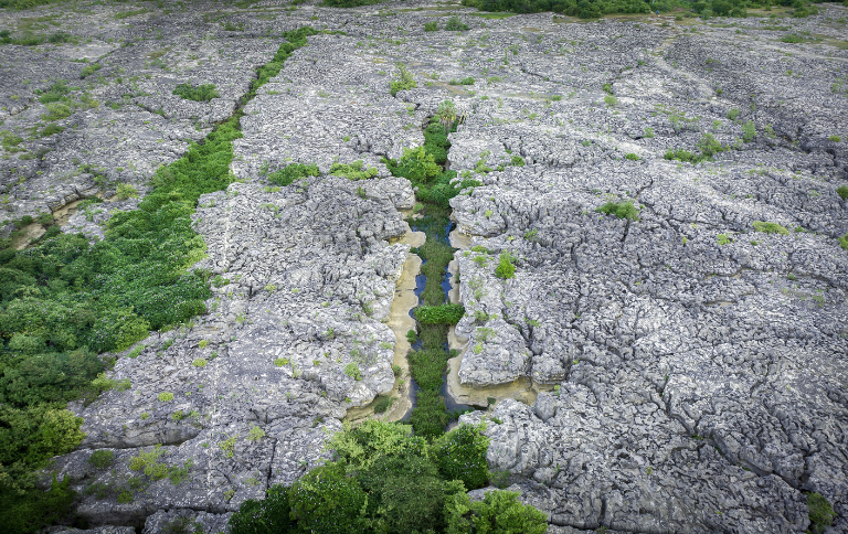
ARARAS SINKHOLE ‣ the largest dry sinkhole in Brazil is Araras Sinkhole, located in NE Goiás state, with about 105m deep and 295m wide, sheltering in its interior a small forest environment in contrast to the low vegetation of its surroundings (Notas Geo | Almanaque Z | G1).

ECOS SUBTERRANEAN LAKE ‣ a lake formed by rainwater, located in the Ecos Cave (the largest mica-schist cave in Brazil and devoid of speleothems), in the municipality of Cocalzinho de Goiás — it is the largest subterranean lake in South America, measuring approximately 300m in length, 50m in width, and between 10-15m in depth, making it one of the longest subterranean lakes in the world (G1 | Wikipedia).

CALDAS NOVAS HYDROTHERMAL COMPLEX (CN) ‣ central Brazil is home to the world's largest geothermal water complex unrelated to magmatism — hot springs emerge along a metamorphic terrain in two main locations in SE Goiás state, 35 km apart: Rio Quente, west of the Caldas dome (12 km lenght, Globo Reporter), featuring moderate temperatures (mean 37.5 °C), and Caldas Novas, east of the Caldas dome, exhibiting relatively higher temperatures, mean 41.9 °C (Lunardi & Bonotto, Geoenergy Science and Engineering, 2025 | Rosa, JWC et al, Journal of South American Earth Sciences, 2021) in 18 springs (Globo Reporter). The exploitation of thermal waters for tourism and leisure has significantly boosted the economy of Caldas Novas and two neighboring towns (D'el-Rey Silva et al, EG'08, 2008). For details, see SIGEP/2005. Many sources highlight the Poço do Ovo, in NE side of Caldas Novas town, whose waters reach up to 57°C, as the hottest natural spring in Brazil (Globo Play | Caldas Novas | IMAGE).

LAGOA AZUL DEEPEST DOLINA ‣ a flooded doline located in the municipality of Niquelândia, Goiás state. It is identified by the Bambuí Group as the deepest dive cave in Brazil with 274m deep (Bambuí Speleo) and is widely cited in popular media as the country’s deepest, often surrounded by the myth of 'having no bottom' (Google Search). Some references suggest depths of up to 320 m (Brasil Mergulho) — however, unfortunately, there is no scientific literature confirming the doline’s depth, volume, funnel morphology, or possible connections with other cavities. An excellent news report about the site can be found on DF1.

ARAGUAINIA DOME ‣ a 40-km impact crater located on the border between the Brazilian states of Mato Grosso and Goiás, near the villages of Araguainha and Ponte Branca — it is the largest known impact crater in South America, the 15th largest in the world (Wikipedia), and the 5th largest in the Southern Hemisphere (Wikipedia).

AROE JARI CAVE ‣ six of Brazil’s twelve speleological provinces are arenitic: Furnas, Itararé, Serra Geral, Altamira–Itaituba, Alto Urubu, and Espinhaço (Zeppelini Filho et al., Papéis Avulsos de Zoologia, 2003). Aroe Jari Cave, located in the municipality of Chapada dos Guimarães in northern Mato Grosso, is the largest sandstone (siliciclastic) cave in Brazil (SIGEP), with approximately 1,550 m of mapped passage — it is extremely flat and contains numerous waterfalls (Wikipedia).

SUCURI RIVER ‣ small river measuring 1,830 m in length (Medeiros, R. B. et al., Revista Geográfica, 2020), located in the municipality of Bonito, Mato Grosso do Sul, is remarkably crystal clear due to carbonate precipitation (Evelio & Piroli, Cadernos de Geografia, 2014). It is popularly regarded on the internet as the clearest river in Brazil and the third clearest in the world (Correio do Estado), although this ranking is more symbolic than academic or scientific.

NHECOLANDIA ALKALINE LAKES ‣ a system of lakes in the Pantanal subregion of Nhecolândia, comprising approximately 10,000 lakes along 24,000 km², predominantly shallow, with sizes ranging from 0.025 to 0.15 km², and primarily characterized by freshwater lakes, known locally as baías, with around 7% being saline-alkaline lakes or salinas (pHs above 9 or 10, high alkalinity and a high density of phytoplankton), surrounded by alkaline soils (Geoderma Regional, 2024) — the unique system of alkaline lakes in Brazil.

SOUTH AMERICAN POLE OF INACCESSIBILITY ‣ the Pole of Inaccessibility of South America — the point on the continent farthest from any ocean, and one of only six such continental points in the world (Wikipedia) — is located in Brazil, at coordinates 14.05°S, 56.85°W, in Diamantino municipality in Mato Grosso state, at a distance of 1,504 km from the nearest coastline (D. Garcia-Castellanos & U. Lombardo, Scottish Geographical Journal, 2007), on private land. In May/June 2023, the exact point was reached by British explorer Chris Brown, who found a machete lying precisely at the location (Brown Site).

BRAZIL/BOLIVIA BORDER ‣ the international border between Bolivia and Brazil, extending from Corumbá (MS) to Assis Brasil (AC), crosses a wide range of landscapes — from large urban areas to remote and inhospitable forests. It stretches for 3,423 km, making it the second-longest land border in America Latina and the 8th longest in the world. On the Brazilian side, it passes through the states of Acre, Rondônia, Mato Grosso, and Mato Grosso do Sul; on the Bolivian side, it runs through the departments of Beni, Pando, and Santa Cruz (Wikipedia).

ACRE/RONDONIA GEOGLYPHS ‣ geoglyphs are earthen excavated structures formed by low walls and ditches that create geometric figures of various shapes. The only known occurrence in Brazil is in an area mostly located in the state of Acre and, to a lesser extent, in SW Amazonas and NW Rondônia. These structures are found in interfluvial areas — between streams, headwaters, and wetlands — primarily associated with the Acre and Iquiri rivers. Despite being restricted to this region, their concentration is remarkably high: in the state of Acre alone, 306 geoglyph-type archaeological sites have been identified, comprising 410 earthen structures (UNESCO). For an accurate map, see Balee, W., et al. (Amazonica, 2014). For an illustrated catalogue listing 187 mapped geoglyphs, including photographs of 76 of them, see Schaan, Ranzi & Barbosa (Book Chapter, 2010).

ACRE/SW AMAZONAS EARTHQUAKE ZONE ‣ earthquakes in South America are typically shallower than 300 km or deeper than 500 km — the deep earthquakes concentrate in two zones: one that runs beneath the Peru-Brazil border and another that extends from central Bolivia to central Argentina (Ciardelli et al., Journal of Geophysical Research: Solid Earth, 2022). Preve, D’Espindula e Valdati (Geografia Física e Desastres Naturais, 2017) list all earthquakes in Brazil with magnitudes above 5 Mb recorded between 1900 and 2017. During this period, 40 events were identified, 27 of which are concentrated in SW Amazonas and in Acre, the most active seismic zone in Brazil, with the remaining ones are distributed across other parts of Amazonas (2), as well as Amapá (2), N Mato Grosso (3), NW Goiás (1), SE Santa Catarina (1), S Minas Gerais (1), Espírito Santo (1), E Pernambuco (1), and N Rio Grande do Norte (1). Among the earthquakes from this SW Amazonas and Acre are the 4 largest events in the survey, as well as 5 of the 7 largest ever documented in the country.

BRAZILIAN WESTERNMOST POINT ‣ a careful examination of 'Atas da 12ª Conferência' of the 2017 Brazil–Peru Joint Commission for the Inspection of Border Markers (PCDL), which revised and updated the international boundary, indicates that the westernmost point of Brazil is Marker 76 (CM Explore Amazonia), a small monument built in 1926 and renovated in 2007, located at the exact longitude of 73°58′59.038″ (despite the popularly cited value of 73°59′26″). However, citizen-science adventurers, during an expedition carried out in 2025 and documented on YouTube (Juruá Aventuras), identified that the true westernmost point lies approximately 600–1,000 m distant of Marker 76, in an area that has not yet been properly developed or officially recognized at the national level. At present, the site is marked only by a sign and awaits formal structuring by the national authorities.

NEGRO/AMAZONAS CONFLUENCE ‣ many river confluences create striking visual effects due to the contrast in water color between the rivers involved — and in Brazil, the most scenic example is the confluence of the black water Rio Negro (flowing at about 2 km/h and a temperature of 28 °C) with the sandy-colored Amazon River/Solimões section (flowing at 4–6 km/h and a temperature of 22 °C). For about 6 km, the two rivers flow side by side without much mixing (Wikipedia).

RIO NEGRO FLUVIAL ISLANDS ‣ the two largest flooded forest systems in the world are both extensive archipelagos located in the lower Rio Negro: the Mariuá Archipelago (approximately 1,400 islands distributed over about 4,000 km², the largest flooded archipelago on Earth, Turismo Barcelos) and the Anavilhanas Archipelago (around 400 islands, the second largest, Ciclo Vivo). Together, these systems sustain a rich fish diversity exceeding 1,000 species (E. M. Latrubesse & J. C. Stevaux, World Geomorphological Landscapes, 2015).

PICO DA NEBLINA ‣ highest point of Sierra de La Neblina or Serra do Imeri mountain range, the maximal point of Brazilian territory, with 2,995.3m. Their summit lies just within Brazilian territory, at a horizontal distance of only 687m from the Venezuelan border. It is highest point east of the Andes in South America, and the second highest outside Andes after Sierra Nevada de Santa Marta in Colombia (Wikipedia), but only the 71st highest in the world (Wikipedia), smaller than the respective for all neighbours except Guianas, Paraguay and Uruguay, evidencing the low altitude of the national territory. Despite having a flat strip on the Venezuelan side, Brazil in Line does not consider Mount Neblina a classic tepui.

SERRA DO ARACÁ TEPUI ‣ it's a massif of tepui type, in NE Amazonas state, being the southermost true tepui of Guiana Shield and the unique tepui enterely in Brazilian territory (Wondermondo | O El Dorado Aqui), with a average elevation from 1,000 and 1,200m and reaches 1,750m at the summit, called peak Aparecida — this tepui comprises metasedimentary rocks represented mostly by quartzite and schist (R. G. Barbosa-Silva et al., The Botanical Review, 2020), and harbors an exceptional diversity of endemic plants, including at least one endemic genus, Yanomamua (Gentianaceae), and the only Brazilian occurrence of Viburnum (Viburnaceae, Siderasis Angiosperms/2022).

MOUNT CABURAY ‣ a table-mountain located on the border between Brazil (Roraima state) and Guyana, standing at 1,465 m above sea level — the source of the Ailã river, located on the mountain, is the northernmost point of Brazil, in 05°16′10″ N (Wikipedia) and the 10th most austral of all those in the Northern Hemisphere (Wikipedia).

MOUNT RORAIMA TEPUI ‣ a charismatic huge tepui (flat-topped mountain), the highest of the Pakaraima Mountain Range, located at the tripoint of Venezuela, Brazil, and Guyana, and surrounded by cliffs 400-1,000 m high. The highest point of the massif lies on the southern edge of the cliff in Venezuela (Pico Maverik, 2,810 m), while another peak at 2,772 m — located at the junction of the three countries, on the northern side of the plateau — is the highest point in Roraima state of Brazil (Wikipedia) — however, recent measurements indicate that the highest point of the tepui lies in the Guianan portion of the massif, at 2,790-2,820 m in elevation (Reddit/Mountaineering). Within the region, the Brazilian section is relatively small, located on the eastern side, and consists of rocky soils, a cliff with tall waterfalls (up to 375m, Cachoeiras Gigantes), and, in its surroundings, the enigmatic Wei-Assipu Tepui — a small tepui that lies of 2,260m entirely within Brazilian territory (Kok et al, Zootaxa, 2011).

ORANGE CAPE ‣ a cape located in an area of tidal marshland, forming both the northernmost point of the Brazilian state of Amapá and the northernmost point of the Brazilian coastline, separated from the coast of French Guiana by the estuary of the Oyapock River (Wikipedia).

SOLSTICE MEGALITHIC MONUMENT OF CALÇOENE ‣ a megalithic observatory (popularly known as the 'Brazilian Stonehenge'), located in Calçoene municipality in the Amapá state, and referred to in academic sources as AP-CA-18 — the largest known megalithic stone circle in Brazil, containing a megalithic stone circle of 127 granite blocks, each up to 4 m tall, standing upright in a circle over 30 m in diameter on a hilltop along the Rego Grande River (Wikipedia | Book Chapter, 2022).

CALÇOENE RAINIEST COAST ‣ Calçoene municipality is the rainiest location in Brazil (ANA/MIP — beside Koppen Brazil Github data, which identifies the cities of São Gabriel da Cachoeira (3619.6 mm) and Japurá (3527.8 mm), both in Amazonas, as the wettest in Brazil, with Calçoene only in 3rd place, with 3344.3 mm), with an average annual precipitation of 4,166 mm, documented over a 30-year period (Portal do Agro), and with extreme records such as in 2000, when rainfall reached 6,902 mm (Tempo e Clima Blogspot). Oliveira, L. L. et al. (IEPA/AP, 2007), analyzing data from station 825002 in Calçoene between 1975 and 2006, found an annual average of 4,238.3 mm, exceeding the value most commonly reported for the site.

DINIZIA EXCELSA TALLEST TREE IN BRAZIL ‣ a specimen of Dinizia excelsa Ducke (Fabaceae), measuring 88.5 m in height and 9.9 m in trunk height (TRT World), located in the municipality of Almeirim, Pará state, near the border with Amapá (G1) makes the species the 11th tallest tree species known, the tallest in America Latina, the second tallest in the tropical world, as well as the tallest non-Malvid angiosperm and the tallest angiosperm in the New World (Siderasis).

POROROCA TIDAL BORES ‣ tidal bores occur in various places around the world where specific geographical conditions exist, especially in areas with significant tidal ranges (Wikipedia | MAP). However, there is no official ranking or comprehensive study that determines the largest and most voluminous tidal bores globally — although the tidal bore in China is often referred to as the most voluminous on the planet (Wikipedia). In Brazil, tidal bores occur from Amapá to Maranhão, in several rivers, particularly near the mouth of the Amazon River, and are collectively known as pororocas. In the Amazon region, these bores can influence river levels over 800 km inland from the sea, making them the most inland-reaching bores known and unquestionably the largest in America Latina (Aguas Amazônicas | Surfer Today | Image/Mongabay), mainly observed on biannual equinoxes in September and March during a spring tide (Wikipedia). Unfortunately, the bore of the Araguari River, another notable one, ceased to exist in 2014 (Mar Sem Fim).

AMAZONAS RIVER MOUTH ‣ the largest fluvial descharge worldwide, with an average of about 215,000 m³/s-230,000 m³/s - approximately 6,591 km³-7,570 km³/y, greater than the next seven largest sea-flow independent rivers - Congo, Ganges, Orinoco, Yang-Tze, Rio de La Plata, Yenissei, Mississipi - combined (Wikipedia). The multiple partitions of the water flows create a network that resembles a delta of estuaries with giant islands and unstable edges, something quite unique on the planet.

AMAZON REEF SYSTEM ‣ one of the largest known reef systems in the World, with scientists estimating its length at over 1,000 km, and its area as over 9,300 km; it is composed by a mosaic of shallow patch reefs (50–70 m), mesophotic reefs (30–220 m depth), large living rhodolith beds and more complex living hard bottoms (formed mainly by fused calcareous algae) inhabited by a diverse reef biota, including threatened and commercially important species (Mahiques et al., Scientific Reports, 2019 | Research Square, 2022 | Revista Fapesp).

MARAJÓ ISLAND ‣ a landmass in northern Pará with a complex geographic setting, particularly regarding its precise delimitation, due to the dense network of rivers and channels in its southwestern portion, with highly variable directions, makes it difficult to define exact boundaries and even conflicts with the very definition of an island. In the commonly cited literature, it is considered the second-largest island in South America and the 35th largest island in the world (40,100 km², Wikipedia), as well as the largest fluvio-marine island worldwide. The island comprises 16 municipalities across its extent and has an approximate population of 557,231 inhabitants (FAPESP/Pará).

A MURALHA GIRTHIEST TREE IN BRAZIL ‣ a tree of the species Ceiba pentandra (L.) Gaertn. (W Mexico to C Brazil and Caribbean, POWO), known as A Muralha, located in Afuá (Marajó island), Pará, is considered the tree with the largest trunk circumference in Brazil and the fifth largest in the world — its circumference, measured at a height of 1.30 m, exceeds 30 m, and the tree reaches approximately 60 meters in height (Monumental Trees).

SERRA DOS CARAJÁS FERRUGINEOUS CAVES ‣ a cluster of ferrugineous cave systems (the largest in Brazil) that includes the Carajás National Forest (FLONA, which balances environmental conservation with the sustainable use of natural resources) and the Ferruginous Fields National Park (PARNA, a fully protected area), located in the SE Pará state (Ruchkys, UA et al, Mercator, 2024), municipalities of Parauapebas, Curionópolis and Canaã dos Carajás, containing approximately 2,300 caves (Anais/CBE, 2017) grouped into five regions: Serra Norte, Serra Sul, Serra do Tarzan, Serra da Bocaina, and Serra Leste (Martins, FD et al, BOOK, 2018). An astonishing diversity of troglobitic animals is also found in these caves, with records of about 150 obligate cave-dwelling species (Brazilian Cave Fauna).

AMAZON MACROTIDAL MANGROVE COAST (AMMC) ‣ located between Marajó Bay (PA) and São José Bay (MA), AMMC is largest continuous area of mangrove forests in the world (Tomaz et al., Revista Brasileira de Climatologia, 2019), and contains the largest and best-preserved mangrove ecosystem in Brazil, with 7,591 km² and 56.6% of all mangroves in country (W.R. Nascimento Jr. et al., Estuarine, Coastal and Shelf Science, 2012), with six species (Menezes et al., Acta Amazonica, 2008), being Halairanthus (Acanthaceae) possibly the tallest mangrove worldwide, with a specime measures 39 m in height, despites reports of 50 m in Colombia (Kjerfve, BOOK/PG31).

SÃO MARCOS BAY HIGH TIDAL ZONE ‣ São Marcos Bay is located in the Gulf of Maranhão, west of Upaon-Açu Island, at the mouth of the Mearim and Pindaré rivers, and covers an area of 2,461 km², making it the largest bay in Brazil by surface area. In addition, it has the greatest tidal range in the country and one of the largest in the world. In São Marcos Bay, near Ponta da Madeira, tides range from 0.4 to 6.0 m between the mean low waters of spring tides and the mean high waters of spring tides, and from 1.5 to 5.0 m between the mean low waters of neap tides and the mean high waters of neap tides. However, tidal heights can exceed 7 m in some sectors of the bay during equinoctial tides (Baías do Brasil | Czizeweski, Dissertation, 2019).

LENÇOIS MARANHENSES SANDFIELD ‣ a large dune field of approximately 1,000 km² and 70km of shoreline, located in NE Maranhão state, being certainly the largest dune field in Brazil — during the rainy season, the valleys among the dunes fill with freshwater lagoons, prevented from draining due to the impermeable rock beneath (Wikipedia | Melo, DB, Revista Brasileira de Ecoturismo, 2024).

PARNAIBA RIVER DELTA ‣ the largest true deltaic formation of Brazil with c. 2,700 km², second in South America after Orinoco one (if we disregard the mouth of the Amazonas as a delta), and 85 islands, composed dune field and mangoves enclosed by the larger Parnaíba River and the smaller Igaraçu River in eastern part, and by tidal channels associated with estuarine-lagoonal conditions in western (Geo-Marine Letters, 2014).

GIANT CASHEW TREE OF PIAUÍ ‣ it is an individual of Anacardium occidentale L., born in Cajueiro da Praia, Piauí state, with a canopy coverage of 8,834 m², and is considered the most expansive tree in Brazil (Cidade Verde | Do Amaral, F.P.M. et al., Genetics and Molecular Research, 2017) and also probably the largest living organism in the country, directly rivaling the cashew tree of Pirangi, Rio Grande do Norte, which covers 8,500 m² (Agro News).

ICAPUÍ SEAGRASS MEADOW ‣ although there are no national rankings in Brazil for seagrass meadows, the most significant fields are located in the Northeast region, particularly the Icapuí meadow on the coast of Ceará state, possibly the largest seagrass meadow in Brazil, which spans an impressive 24 km in width (Deeks et al, ESI, 2024).

ATOL DAS ROCAS ‣ is a small atoll off northern Brail, only in the South Atlantic Ocean and around South America, at Rio Grande do Norte state jurisdiction, and located approximately 260 km northeast of Natal and 145 km west of the Fernando de Noronha archipelago; the atoll is of volcanic origin and coralline formation, has two small islands and none permanent population (Wikipedia).

FERNANDO DE NORONHA ISLANDS ‣ an archipelago extremely popular in Brazil, located in the Atlantic Ocean off the northeastern coast, it is the most important group of Brazilian oceanic islands in terms of area (18.4 km² across 21 islands), historical significance (visited as early as the 16th century), and the only one with a permanent population (estimated at 3,101 inhabitants in 2020). Administratively, it is a state district of Pernambuco and is located approximately 354 km off the Brazilian mainland. Its highest point reaches 323 m above sea level. Beyond tourism, it is a highly strategic area of Brazilian territory from a geopolitical perspective and a major focus of intensive scientific research in several fields, including maritime studies, geology, and biodiversity (Wikipedia).

ILHA DO MEIO SUBMARINE CAVE ‣ in Brazilian coast, 7 locations are known to host submarine caves (G1 | Muricy, G. et al., Journal of Marine Science and Engineering, 2024 | Moraes, F., et al., RBEsp, 2025): Trindade island (ES, 1 cave), Ilha Redonda (RJ, 1 cave), Arraial do Cabo (RJ, 1 cave, 33m deep, SEE), Tamandaré (PE, 6 caves), Abrolhos (BA, 1 cave, 12m long, SEE), Atol das Rocas (RN), and Fernando de Noronha (PE). There are no comprehensive data on the total extent of these caves, but the Ilha do Meio submarine cave in Fernando de Noronha (also called Meia Lua Cave), measuring 60m in length, is likely the largest submarine cave in the country. It harbors a rich sponge community, including three species recorded in its aphotic zone, representing one of the few — or possibly the only — known communities living in complete marine darkness along the entire Brazilian coast. A list of the world’s 160 longest sea caves can be consulted on Cave Exploring/World Longest Sea Caves.

SAINT PETER AND SAINT PAUL ROCKS ‣ a group of 15 small islets and rocks with 0.17 km² of area, located in the central equatorial Atlantic Ocean in the Intertropical Convergence Zone, a region of the Atlantic characterized by low average winds punctuated with local thunderstorms. Its lies approximately 940 km from the nearest point of mainland South America (town of Touros), 625 km northeast of the archipelago of Fernando de Noronha and 1,824 km from the west coast of Africa. This grouping is the sole location in the Atlantic Ocean where the abyssal mantle is exposed above sea level (Wikipedia | Pesquisa Fapesp/The exposed depths of the Earth).

PICO DO CABUGI EXTINCT VOLCANO ‣ located in the municipality of Angicos, in Rio Grande do Norte state (Clube Candeias), NE Brazil — it is one of several volcanic necks of the Tertiary alkaline basaltic province of Rio Grande do Norte and represents the youngest continental magmatism in Brazil (19.7 Ma) and the only extinct volcano in Brazil that still preserves its original shape. The peak rises roughly 500 m above the surrounding plain, making it one of the highest points in the state (SIGEP). Interestingly, a growing number of historians and researchers argue that Pico do Cabugi — rather than the traditionally cited Monte Pascoal in Bahia — was the landmark first sighted by the Portuguese upon their arrival in 1500 (Uol Educação).

PARAIBA TOURMALINE MINE ‣ Brazil is a true powerhouse of gemstones, hosting an impressive diversity of precious stones, many of them highly valuable and remarkably rare. However, the most notable of all is the Paraíba tourmaline — despite the opal from Piauí, which is interesting but neither as rare nor as valuable. Once exclusive to Brazil, Paraíba tourmaline (a variety of elbaite rich in copper, containing between 0.37% and 2.47% CuO by weight), ranging from electric blue to neon green and, in rarer cases, violet, is now also found in deposits in Nigeria and Mozambique, although these foreign occurrences generally produce material of lower quality than the Brazilian stones (Brazil Paraiba Mine). It is the rarest and most valuable of all tourmaline varieties, occurring in Brazil exclusively within the Borborema Pegmatite Province (Desgeoeduorg), which spans areas of the states of Paraíba and Rio Grande do Norte. Currently, there is only one legally active mine (Acdmin), operated by Brazil Paraiba Mine, in the municipality of Parelhas, Rio Grande do Norte.

BRAZILIAN MAINLAND EASTERMOST POINT ‣ Ponta do Seixas Cape, also known as Cabo Branco Cape, is a headland on the Atlantic coast of the state of Paraíba, in NE Brazil. It marks the easternmost point of Brazil and of the mainland of the Americas (34°47′34″ W), located approximately 8 km southeast of João Pessoa, the state capital (Wikipedia), also considered the 14th easternmost point among all countries that lie west of the Greenwich meridian (Wikipedia).

ROCK OF INGÁ ‣ an archaeological monument of exceptional value, consisting of a gneissic rock formation covering approximately 250 m² - its main feature is a vertical wall about 50 m long and 3 m high, on which numerous carved figures appear (aproximmately 400), suggesting representations of animals, fruits, humans, and constellations such as Orion. The site is located in the municipality of Ingá, in Paraíba state, NE Brazil (Wikipedia | Brito, A Pedra do Ingá, 2009).

BRAZILIAN DRIEST PLACE ‣ Cabaceiras municipality, in the state of Paraíba, is the driest location in Brazil (although the Köppen Brazil GitHub site lists it only as the fifth driest, after three other municipalities in Paraíba and one in Pernambuco, all above 409mm/year), with an average annual precipitation of 336.6 mm over 86 years of observations, a maximum extreme of 775.5 mm recorded in 1964, and a minimum extreme of just 23.8 mm in 1952 (Breckam et al., Revista de Educação Agrícola Superior, 2013).

GIANT MANDACARU OF SANTA CRUZ DO CAPIBARIBE ‣ the tallest cactus species is generally attributed to two candidates: Carnegiea gigantea (up to 23.7 m, blowing over in a windstorm in 1986, AZ Animals) and Pachycereus pringlei (endemic to NW Mexico, up to 20m, Guinness Book). However, no official source includes the mandacaru, Cereus jamacaru, endemic to Brazil, in this ranking — a cultivated specimen in the rural area of Santa Cruz do Capibaribe, Pernambuco, has reached 22m in height (Merece Destaque), making it likely the tallest living cactus worldwide and placing this Brazilian species as the tallest (though not the most massive) member of this remarkable family.

SANTANA LAGERSTÄTTEN ‣ Lagerstätten are sedimentary deposits — fossil sites — that exhibit exceptionally well-preserved fossils, often including soft tissues being two main types: Konzentrat-Lagerstätten (concentration) and Konservat-Lagerstätten (conservation). Comprehensive checklists of Lagerstätten can be found on Wikipedia (SEE) and Lagerstätten of the World (SEE). Both sources list the Santana Formation, located in the Araripe Plateau — spanning the Brazilian states of Ceará, Pernambuco, and Piauí — as one of the most remarkable Lagerstätten in the world and, without doubt, the most important Lagerstätten in Brazil dating to Early Cretaceous and subdivided into three members: (1) the Crato Member (lower), characterized by calcarenites, algal laminites, shales, and laminated limestones; (2) the Ipubi Member (middle), composed of evaporites, dark shales, and limestones; and (3) the Romualdo Member (upper, SEE), consisting of sandstones, shales, limestones, and marls, with carbonate concretions that often contain fossils. For an excellent list of vertebrates from the Santana Formation, see Boos & Vega (Acta Biológica Paranaense, 2011). For a highly didactic and detailed overview of the formation, refer to Paleocrias Blogspot (SEE).

SERRA DA CAPIVARA ARCHEOLOGICAL PARK ‣ a flat-topped, cliff-bounded plateau that possibly hosts the largest and oldest concentration of prehistoric sites in the Americas — both archaeological and paleontological — despite widespread debate over the proposed chronologies put forward by Brazilian researchers (Current World Archaeology, Issue 37). The area contains approximately 1,300 prehistoric sites, about 900 of which feature rock paintings, in addition to well-established human fossils dated to around 9,300 years BP (Lourdeaux, Boletim do Museu Paraense Emílio Goeldi, 2019 | Revista Fapesp).

VIOLETO ARTESIAN WELL ‣ there is an extreme lack of information about the artesian wells in Brazil. As artificial structures with a natural flow, they represent a unique category in hydrogeology. It is known that between 264, 300 (SEE), 350 (SEE) or 500 such wells are scattered along a strip about 30 km wide on each side of the Gurguéia River in southern Piauí state (Conejo, ANA, 2005), within the Cabeças Aquifer area, whose spontaneous water discharge is due to the confinement of the Cabeças and Serra Grande aquifers by the Longá and Pimenteiras formations, respectively, throughout the entire valley (about 400 km), ensuring shallow static levels and, occasionally, flowing artesian conditions, which reduce the cost of water extraction (Feitosa, CPRM, 2010). Considerable controversy surrounds these wells, especially regarding the high level of water waste they represent (Folha de S Paulo, 2000). The largest artesian well of Brazil, Violeto I, located in Alvorada do Gurguéia, currently reaches about 25 m in height, though older reports describe jets as high as 70 m. Some sources even describe it as the second largest in the world of its kind — without specifying which one would be the first (Click Petroleo e Gás, 2025).

MIDDLE SÃO FRANCISCO PALEODUNES ‣ a complex of two inative 'fossil' sand fields in left side of Rio São Francscio in NW Bahia state, the largest paleodunes in Brazil: a western bank field, with c. 88 km², and eastern bank with c. 200 km², composed by 'fossil' dunes with heights between 5-10 m to 50-60 m, with an average between 15 and 25 m, and horizontal extent most commonly between 1-3 km, but some parabolic dunes can be over 10 km (SIGEP/CPRM). For trekking in the region, see Youtube/Dunas do Pilão Arcado-BA.

TOCA DA BOA VISTA CAVE ‣ In Brazil, 42 caves are 4 km or longer, but only Toca da Boa Vista Cave exceeds 100 km (Bambuí Speleo). Composed of dolomites, it is located in the municipality of Campo Formoso, in N Bahia state, and is the largest cave known in Brazil (114 km) and the third in the Southern Hemisphere (after the Marosakabe Cave in Madagascar, with 124 km, and the Builita Cave in Australia, with 123 km), it ranking 23rd in the world (Wikipedia | SIGEP/CPRM | LinkedIn).

BENDENGÓ METEORITE ‣ the largest known Brazilian meteorite to date, weighting 5.36 tons and measuring 2.15 m ✕ 1.5 m ✕ 65 cm, with a somewhat flattened shape, resembling a riding saddle, and composed mainly of iron and nickel, with smaller amounts of other elements. Despite its colossal size, it's the 16th largest meteorite today, although it was the second largest in weight and size at the time of its discovery, and was found in the interior of Bahia (in the region where the municipalities of Monte Santo and Uauá are located today) and is now housed in the meteorite hall of the National Museum in Rio de Janeiro (Meteoríticas | Carvalho, W.P. et al., Revista Brasileira de Geociências, 2011).

NORTHERN BAHIA ARID ZONE ‣ it is widely recognized in Brazilian geographic culture that the northeastern semi-arid region is the driest part of the country. In addition, there is broad agreement in identifying a vast area in northern Bahia and southern Pernambuco as the most arid portion of Brazil (MAP | MAP | MAP). This area includes, within its diffuse perimeter, the first technically arid region identified in Brazil, a area of 5,763 km² located in the NC Bahia and covering the entire area of the municipalities of Abaré, Chorrochó and Macururé, in addition of area of Curaçá, Juazeiro and Rodelas, municipalities in Bahia that border the Pernambuco hinterland, revealed in a 2025 study (CEMADEN | MAP) and widely reported in the media (G1), with an aridity index of less than 0.2. It also comprises all sites classified as BSh — hot arid climate — in the Köppen system (Wikipedia), as well as the Raso da Catarina, a striking landscape often portrayed in the media as the 'Brazilian Atacama' (Fundaj | The Summer Hunter), with physiognomic similarities to the desert chaparrals of N Mexico, the margins of the Kalahari, or the Australian scrublands. This region does not, however, include geographic forms typical of true deserts, such as extensive dune fields, sandstorms, oasis, or salt flats.

AGUAS CLARAS CAVE SYSTEM (ACCS) ‣ a cave system located in the municipality of Carinhanha (Bahia), approximately 24 km in length and composed of four limestone caves (Marconi Souza-Silva et al., Biodiversity and Conservation, 2021), recognized as the richest hotspot of subterranean biodiversity in the Neotropical region — 41 identified troglobic species across the following groups: Hexapoda (14), Arachnida (10), Isopoda (6), Diplopoda (7), Gastropoda (2), Turbellaria (1), and Actinopterygii (1). This system surpasses Toca do Gonçalo (also in Bahia) and the Areias cave system (southern São Paulo state), the only other two subterranean biodiversity hotspots known in South America (R. L. Ferreira & Marconi Souza-Silva, Diversity, 2023).

PERNA DA BAILARINA STALACTITE ‣ the world’s largest stalactite, located in the Peruaçu Caves National Park, at the entrance of the Janelão Cave. It measures 28m in length, the result of a slow and continuous geological process that began around 140,000 years ago, with a growth rate extremely slow — about 1cm/100y (Revista Oeste | G1).

BRAZILIAN TEKTITE'S FIELD ‣ tektites, a rare type of impact glass, are known to occur only in six distinct strewn fields on Earth: from the W USA to the Lesser Antilles; in Belize and Guatemala; between Senegal and Nigeria in Africa; in E Europe; across a vast area from Madagascar to S China, the Philippines, and Australia; and in N Minas Gerais state in E Brazil, the unique tektite field in South America, forming a collection of approximately 500 fragments found within a strewn field at least 90 km long, mainly in the Taiobeiras, Curral de Dentro, and São João do Paraíso municipalities near the border with Bahia state — mostly black in color, the masses, hereby named 'geraisites' after the Brazilian state of Minas Gerais, range from less than 1 g up to 85.4 g and exhibit various shapes, rarely showing lechatelierite inclusions (A.P.Crósta et al, Geology, 2026 | Crater Explorer).

ABROLHOS REEFS ‣ Abrolhos reefs represent the most extensive and richest coral reef area in Brazil and in the SW Atlantic, occupying approximately 6,000 km² of the northern Abrolhos Bank (an enlargement extending up to 200 km offshore from Caravelas, from the southern part of the generally narrow — average width of 50 km — Eastern Brazilian continental shelf), and are comprised of two reef arcs (Coastal and Outer Arcs) almost parallel to the coast, as well as volcanic islands, sand shoals, and channels (Leão & Kikuchi, The Abrolhos Reefs of Brazil, 2001).

WORLD LARGEST RHODOLITH BED ‣ rhodoliths are nodules of non-geniculate coralline algae that occur in shallow waters (few 150 m depth) subjected to episodic disturbance. Rhodolith beds stand with kelp beds, seagrass meadows, and coralline algal reefs as one of the world's four largest macrophyte-dominated benthic communities, with large concentrations off Japan, Australia and the Gulf of California, Mediterranean, North Atlantic, eastern Caribbean and Brazil. Abrolhos Shelf (16°50′ - 19°45′S) off E Brazil (Bahia and Espírito Santo states) is confirmed the most expansive and contiguous rhodolith bed in the world, covering about 20,900 km² (Amado-Filho, AM et al., Plos One, 2012).

MUCURI CLIFFS ‣ in some points of the coast there are cliffs, a good part of sandy geology. In Brazil these forms occurs in Beberibe, Aracati, Icapuí (CE), Touros, Tibau do Sul (RN), João Pessoa (PB), Roteiro (AL), Mucuri (BA), coast of São Paulo, and highly disjunct in Torres (RS), as independent systems (Saiba Mais, 2021). The site Almanaque Z considers a stretch of Mucuri Cliffs as the longest contunuous in Brazil (SEE), with 2,7 km lenght.

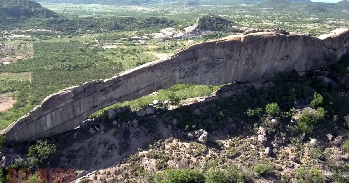
PEDRA RISCADA ROCK ‣ the largest monolith in Brazil and also the largest rocky wall in Brazil, with 950m of extension between base and summit, located in E Minas Gerais state in São José do Divino Municipality, and with a summit reaching 1,230m above sea level — it's sometimes assinated as the largest monolith of the world (CBG/2017).

GANDARELA GIANT PALEOBURROW ‣ approximately 2,000 paleoburrows have been found in South America, mostly in southern Brazil, Uruguay, and Argentina (The World | Frank et al., SBP Monographies, 2012), with a record also in Rondônia state (G1). The Gandarela Giant Paleoburrow, in the municipality of Caeté, southeastern Minas Gerais state, is possibly the largest in the world, with a length of 345 m (Ruchkys et al., Caderno de Geografia, 2014 | Carmo FF et al, MPMG, 2024 | Aventure Box).

MONTE CRISTO CHEMOSYNTHETIC CAVE ‣ within a broad concept of chemosynthetic caves, the Monte Cristo Cave can be considered a potential candidate for being the first — or possibly the only — chemosynthetic cave in Brazil. This quartzite cave, located in Diamantina, Minas Gerais state, is distinguished by its peculiar characteristics, including strong nutrient limitation, elevated CO₂ concentrations, and a unique microbial community (especially members of the class Ktedonobacteria, also possess a high diversity of genes involved with different biogeochemical cycles, including reductive and oxidative pathways related to carbon, sulfur, nitrogen, and iron). The cave has been studied as an analog model for life on Mars and exhibits a high diversity of genes involved in iron and manganese cycling, with significant implications for astrobiology and biotechnology (Bendia, A. et al, Astrobiology, 2021 | Firrincieli, A. et al., BiorXiv, 2025).

CENTENARIO CAVE ‣ only 10 Brazilian caves reach depths of 200 m or more — Centenário Cave, located in the municipality of Mariana, Minas Gerais state, is the deepest cave in Brazil, with depths reported of 484 m (Bambuí Speleo), and is also the deepest quartzite cave in the world (SIGEP). A list of the world’s 410 deepest caves, all deeper tham Centenario Cave, can be consulted on Cave Exploring/World Deep Cave.

PICO DA BANDEIRA/CAPARAÓ MASSIF ‣ the highest point of Serra do Caparaó Massif, the second highest maximal point in Brazil (2,896.2m), situated on the border of Espírito Santo and Minas Gerais states, being the highest point in both states and historically considered the highest mountain in Brazil until 1965, when Pico da Neblina, next to the Venezuelan border, were explored, measured, and both found to be higher. This mountains is also remarkable for being the Brazilian mountain with the greatest topographic isolation: 2,344 km — in the Americas, only Aconcagua, Denali, Pico de Orizaba and Mount Whitney are more topographically isolated than Pico da Bandeira, and in the entire world, there are only 20 more isolated mountains (Wikipedia).

PALMAS LAKE ‣ a lake located in Linhares municipality in Espírito Santo state, with a maximum depth of 50.7m, a volume of 0.22 km³ and a mean depth of 21.4 m, being the deepest natural lake in Brazil (Barroso et al., Plos One, 2014). Several aerial images in YT/Linhares Empregos.

LAGOA JUPARANÃ ‣ also in Espírito Santo state, this lake is the largest (62.58 km², Amorim Gonçalves, Dissertation, 2015) and most volumous freshwater lake enterely in Brazil (0.5281 km³, estimative of Almanaque Z), and second of both features in country, in both cases after Mirim Lake (see below) which reaches into Uruguay.

LEATHERBACK TURTLE NESTS IN BRAZIL ‣ in Brazil, the only area where regular nesting by the Leatherback Sea Turtle (Dermochelys coriacea, the largest living Testudines) is known to occur lies along the northern coast of the state of Espírito Santo, around latitude 19°S, primarily on Comboios Beach. Between the 1988–1989 and 2003–2004 nesting seasons, 527 nests were recorded in the study area, with annual counts ranging from 6 nests in 1993–1994 to 92 nests in 2002–2003 (Thomé, JCA et al, Chelonian Conservation and Biology, 2007). Occasional nesting events have also been reported in Rio Grande do Norte, Bahia, Rio de Janeiro, Santa Catarina, Rio Grande do Sul, and Piauí (ICMBIO).

BRAZILIAN KELP FOREST ‣ Brazil has the unique kelp forests of tropical Atlantic Ocean in Americas (Wernberg et al., World Seas, 2019 | Jayathilake et al., Biological Conservation, 2020), composed by endemic Laminaria abyssalis A.B.Joly & E.C.Oliveira, a deep tropical species prostrate growing up to 5-6m long, from N Espírito Santo coast up to C Rio de Janeiro states, in a small atrea of 33,000 km² (Ictiolab/2021 | Fernandes et al., BOOK, 2021).

TRINDADE AND MARTIM VAZ ISLANDS ‣ Trindade and Martim Vaz are two archipelagos with a combined area of 10.4 km², located in the South Atlantic Ocean, about 1,100 km east of the coast of the Brazilian state of Espírito Santo, forming the most isolated portion of Brazilian territory, comprising six islands and numerous rocks. Trindade is a mountainous, desiccated volcanic island, with numerous phonolitic lava domes and steep-sided volcanic plugs reaching elevations of up to 620 m. South Island, near Martim Vaz, marks the easternmost point of emerse Brazil (28°51′00″W). On Trindade, there is a small settlement on the northern coast, on the shore of a cove known as Enseada dos Portugueses, which supports a Brazilian Navy garrison (Wikipedia).

BRAZILIAN ATLANTIC DEEPEST POINT ‣ the lowest point of the Brazilian EEZ and, therefore, of the entire national territory, can be found by accessing the Ocean Basemap (SEE), activating 'layers', selecting ArcGIS Online mode, searching for 'Brasil ZEE', and activating the correct layer for a visual search. Then, the Bathymetric Data Viewer (SEE) helps to obtain the exact point. The exact point is located at the approximate coordinates of 25°43'12" W 19°25'40.8" S, reaching a depth of -6182m, and does not have an official name, being 348 km from Martim Vaz island and 1,430 km from the mainland, at the latitude of Bahia.

CABO FRIO UPWELLING ‣ upwelling is a phenomenon in the oceans where cold deep waters rise to the surface of the sea, in complex systems involving the Coriolis effect, wind systems, and the rotation of the Earth. The largest systems are located off the western coasts of continents, although they occur at various points (Long & Minh-Thu, Vietnam Journal of Marine Science and Technology, 2022). Coastal upwelling occurs on the Brazilian shelf in three different regions: off southern Bahia (15° S–19° S), off Cabo Frio (20° S–24° S), and off Cabo de Santa Marta (Kaempf & Chapman, BOOK, 2016), being the most prominent of these systems is the Cabo Frio Upwelling System (CFUS), with spatial extension of the upwelling and the temperature anomalies associated with it are about 500 km and -4.5°C at 23°S, respectively (Santos, F.H. et al., SBSR, 2015). This phenomenon makes the waters significantly colder compared to the ambient temperature, especially between August and September, while also providing a high density of nutrients (Olhar Oceânico, 2023).

BRAZILIAN ASPHALT SEEP ‣ Brazil has only three chemosynthetic ecosystems at their sea, one is Brazilian aspahlt seeps, escarpment of asphalt on the seafloor relief off Espirito Santo state, discovery only in 2013, the only representing only the third discovery of this type of seep worldwide, following those in the Gulf of Mexico and off Angola (Fukujima et al., DSRP II, 2017). Brazilian asphalt seeps has a total length of approximately 5.6 km (Jiang et al., Scientific Reports, 2018).

LAGOA SALGADA ‣ a small salt lake in the municipality of Campos dos Goytacazes, on the northern coast of Rio de Janeiro state, that contains the only known occurrence of recent columnar carbonate stromatolites in Brazil, and probably in South America (SIGEP | Geoparques Costões e Lagunas | Ambiente Cult).

LAGOA ARARUAMA ‣ located in Rio de Janeiro state, extending across six municipalities, it is the largest body of permanent hypersaline water in the world, with an area of 220 km², surpassing other prominent hypersaline water bodies such as the Great Salt Lake (USA), Lake Coorong (Australia), Lake Enriquillo (Dominican Republic), and Laguna Ojo de Liebre in Mexico (Wikipedia), being also the second-largest saltwater lake in Brazil, after Mangueira Lake.

FORNO BEACH PINK SANDS ‣ there is no official catalog of the number of beaches in Brazil - however, Guia 4 Rodas, a popular Brazilian travel and automotive magazine, listed 2,095 beaches in its 2007 edition (Mar Sem Fim). There is also no official survey in the country regarding beaches with non-conventional sand colors — typically in shades of black or pink. Among Brazilian beaches, Praia do Forno in Arraial do Cabo, Rio de Janeiro, is often mentioned for having pink sand, caused by the weathering of garnet mixed with shells and corals (Viagem e Turismo | Turismo Buzios). It is included in such lists due to its remarkable aesthetics and because it is the most widely known national example under this criterion.

NEBLINA WATERFALL ‣ Brazil has 28 waterfalls that are 200 m tall or higher, spread across eight states and mostly concentrated in the southern region — however, the tallest waterfall in Brazil of them is Neblina Waterfall, standing at 450 m high, located in the Serra dos Órgãos National Park, in Guapimirim municipality, Rio de Janeiro state (Cachoeiras Gigantes).

ROCK OF GAVEA ‣ a monolithic rock in Tijuca Forest, Rio de Janeiro city in Rio de Janeiro state, Brazil, composed of granite and gneiss, its elevation is 844m, being the world's largest monolith on the coastline (Wikipedia).

OLDEST JACARANDA OF ITUTINGA ‣ a xylopodic individual of Jacaranda decurrens Cham. (Bignoniaceae, native to C Brazil, Paraguay and Bolivia) from Itutinga, in southern Minas Gerais state, with an estimated age of 3,801 years, is probably the oldest living organism in Brazil and the oldest angiosperm in America Latina, surpassing an individual of Fitzroya cupressoides (Mol.) Johnst. (Cupressaceae) from Chile, which has an age of 3,622 years (Alves, R. J. V. et al., Anais da Academia Brasileira de Ciências, 2013). The oldest known organism is likely a specimen of Posidonia oceanica (L.) Delile located near the Balearic Islands in Spain (Wayback Machine).

HIGHEST SPRING IN BRAZIL ‣ there are no official records in Brazilian scientific literature identifying the highest spring in the country, nor are there consolidated data on springs located in Brazil’s highest mountain ranges. However, a strong candidate for this title — and considered one of the nation’s natural treasures — is a spring located east of the summit of Pico das Agulhas Negras in Minas Gerais's side (see in map at PN Itatiaia), the highest peak of the Itatiaia massif, at an elevation of approximately 2700 m. If a higher spring does exist, it is likely to be found in either the Caparaó Massif or the Neblina Massif.

SERRA DA MANTIQUEIRA ‣ a mountain range formsing the highest continuous orographic system in eastern South America (Marques Neto, Revista Brasileira de Geomorfologia, 2017) and is one of the country’s oldest and most significant mountain complexes (Cipriano da Silva et al., Revista Ciência Afronômica, 2022). In the more conservative definition adopted here, it extends across NE São Paulo, SE Minas Gerais, and SW Rio de Janeiro states (Teramoto & Vilanova, Journal of South American Earth Sciences, 2024), within the Atlantic Forest domain — known for its exceptional species richness and endemism (Campos-Mota et al., Phytotaxa, 2022). The range contains 5 of Brazil’s 8 maximal points (Almanaque Z/2025), as well as the nation’s highest city and several other altitude-related records.

CAMPOS DO JORDÃO ‣ the highest settlement in Brazil (46,974 inhabitants in 2022, IBGE), with its seat located at 1,639.2 m above sea level (IBGE) — however, the city's urban sprawl extends into even higher areas, with streets and residences reaching elevations above 1,700 m on the Campos do Jordão Plateau, a crystalline block plateau bounded by steep escarpments that rise approximately 1,500 m above the hills of the middle Paraíba Valley, in the NE part of the state of São Paulo (Modenesi-Gauttieri & Hiruma, Revista do Instituto Geológico, 2004). In the ranking of the largest settlements by country, Campos do Jordão holds the distant 69th position worldwide and the 16th in the Americas (Wikipedia).

RIACHO SUBTERRANEO CAVE ‣ the largest granitic cave in southern Hemisphere and sixth worldwide in this lithology, located in Itu municipality in São Paulo state, with 1415m long (Bichuette et al, Neotropical Biology and Conservation, 2017).

QUEIMADA GRANDE SNAKE ISLAND (QGSI) ‣ an island of 0.45 km² off the coast of Brazil in the Atlantic Ocean at 35 km of continent, famous for its abundant snakes (Bothrops insularis Amaral, 1922, 2,000 to 4,000 snakes, Discover Wild Life), administered by municipality of Itanhaém in São Paulo state, covered by bare rock to rainforest (Wikipedia). This island ranks second worldwide in snake concentration, surpassed only by Shedao Island in China, which harbors around 20,000 snakes. A second snake species, Dipsas mikanii Schlegel, a non-venomous species, is also found on the island (National Geographic Brazil). In 2025, MrBeast — then considered the world's biggest YouTuber — named QGSI the most dangerous place on Earth, cementing the island’s place in global pop culture (G1).

CASA DA PEDRA CAVE ‣ only five caves in Brazil have entrance portals measuring 70 m or more (Bambuí Speleo), the largest of which is the entrance of the Casa da Pedra cave — a cave located within forested mountains in the southern part of the state of São Paulo (Iporanga municipality), in the Atlantic Forest region. It is the largest cave entrance in the world, recognized by the Guinness Book, with an astonishing height of 215 m (PETAR).

RIO FRIA TUFA CAVE ‣ caves formed by the growth of tufa are relatively uncommon. Only two are registered in the Cadastro Nacional de Cavernas of the Brazilian Speleological Society (consulted on 28 January 2011, although cavities formed by tufa growth do occur in the Serra da Bodoquena, along the Mimoso River, but remain unregistered): Abrigo-sob-rocha do Caxangá (Rio de Janeiro state) and Rio Fria Cave, Barra do Turvo municipality, the largest and most emblematic example of this highly singular type of cave in Brazil, with only 80 m of mapped length and an elevation difference of 11 m (Sallun Filho et al, Espeleo-Tema, 2011).

ASA-DE-VIDRO BUTTERFLY AGGREGATION ‣ large butterfly clusters around the world are strongly associated with Mexico’s Monarch butterflies, and deservedly so — however, similar events have been recorded in other parts of the world, including in SE Brazil, albeit on a much smaller scale. Notably, substantial aggregations of the species Epityches eupompe (Geyer, 1832), native from Bahia state to NE Argentina (Tropical Lepidoptera Research, 2017), probably related to migration and overwintering, have been documented at four sites: Iporanga (Intervales State Park, SP, 2017), Corupá (SC, 2017), Santos (Quilombinho River, SP, 2023), Anhangava (Serra da Baitaca State Park, PR, 2023), observations occurred during winter, in Ombrophilous Dense Forest areas of the Serra do Mar mountain range, near streams. The lethargic behavior of the adults, combined with the absence of larval host plants, signs of herbivory, or any evidence of mass emergence, suggests that these aggregations do not represent sites of growth and reproduction, but rather provide climatic shelter for adult butterflies (Shirai, LT et al., Tropical Lepidoptera Research, 2024).

PEABIRU ANCIENT ROUTES ‣ a ancestral network of trails dating back more than 3,000 years connected the Atlantic and Pacific Oceans, running through Brazil, Paraguay, and Bolivia, and reaching as far as Peru (some branches extend toward Mato Grosso do Sul, Argentina, and Rio Grande do Sul, Atlas do Chão). This network is highly controversial (rejected by National Institute of Culture of Peru, Campo Grande News), marked by disputes among government agencies, civil organizations, historians, and authorities (IELA/UFSC), and strongly fueled by theories and speculation. Existing maps of the route are vague, and rigorous surveys are still underway (Blog Caiçara). In Santa Catarina state, the Peabiru is associated with the saga of Aleixo Garcia, often cited as the first European to reach the Andean Empire (Cultura Uol | DW). In the state of São Paulo, the Peabiru is believed to have branched across the southern and central regions, extending up to 5,000 km (Melhores Destinos). In Paraná, mapping efforts are more advanced, producing a more detailed route that includes 97 municipalities (Caminhos do Peabiru | MAP). The routes of the Peabiru in Paraguay, Bolivia, and Peru remain unknown or highly imprecise.

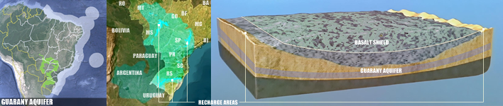
GUARANY AQUIFER ‣ often mistaken as 'an underground lake or river', aquifer are like an underground sponge — buried layers of sand and gravel saturated with water. Guarani Aquifer System represents the second largest aquifer in the world (after Great Artesian Basin, in Australia, SEE) and the largest in Brazil, occupying 950,000 km² within the Paraná sedimentary basin at 8 states, reaching also in othre three countries: Argentina, Paraguay, and Uruguay; 90M people are directly or indirectly benefitting from the GAS exploitation (Teramoto, Gonçalves & Chang, Journal of Hydrology: Regional Studies, 2022).
GUARTELÁ CANYON ‣ a Brazilian canyon located on the Campos Gerais plateau, between the municipalities of Castro and Tibagi in the Paraná state — it is considered the sixth longest canyon in the world and the longest in Brazil. The Guartelá Canyon is a straight, narrow gorge measuring approximately 30 km in length, with a maximum depth of 450 m. It was carved by the Iapó River, which cuts through the devonian escarpment— the geological wall that separates the first and second plateaus of Paraná (Wikipedia).

IGUAZU FALLS ‣ extremely famous waterfalls of the Iguazu River on the border between the Argentine province of Misiones and the Brazilian state of Paraná — together, they form the 8th most voluminous waterfall system in the world (after 3 in Africa, 2 in North America, 1 in SE Asia and Pará falls in Venezuela, ignoring Paulo Afonso Falls, which has an artificial flow resulting from damming, Wikipedia) and the largest in Brazil, 35–40 m in height, with an average discharge of 1,746 m³/s; the maximum recorded flow was 45,700 m³/s on 9 June 2014 (Wikipedia).

PARANÁ LAVA TUBES ‣ in Brazil, only four lava tubes are known: Casa de Pedra and Perau Branco (both in the municipality of Palmital), Dal Pae (municipality of Marquinho), and Pinhão (municipality of Pinhão), all located in southern Paraná state (SINAGEO/2016). For details on the first two, see Waichel, B.L. et al (Journal of South American Earth Sciences, 2013). A list of the world’s 846 longest lava tubes can be consulted on Cave Exploring/World Lava Tubes.

SOUTH AMERICAN TORNADOES ZONE ‣ southeastern South America has one of the most active corridors on the planet, spanning mainly N Argentina, S Brazil, Uruguay, and Paraguay, being one of the most dynamic and violent meteorological environments in the Southern Hemisphere — the USA is the world leader in recorded tornadoes — averaging about 1,225 per year (G1). Almeida (IC/UEPG, 2023) lists records of tornadoes from 1978 to 2018 indicate 581 events in Brazil, spread across 422 municipalities, 159 of which reported more than one occurrence — the southern states dominate overwhelmingly (411): Rio Grande do Sul (180), Santa Catarina (142), and Paraná (89). The two areas in Brazil with the highest density of tornado records are a belt extending from SW Paraná to NE Rio Grande do Sul states, and a cluster located in NE São Paulo state.

AMETHYST WORLD LARGEST MINES ‣ amethyst is a variety of quartz containing tetravalent iron ions, which give it its purple color — quite common in Brazil and occurs in several lithologies. However, commercially valuable forms are far rarer and more spatially restricted. The region of Ametista do Sul hosts one of the largest amethyst deposits in the world, due to the concentration and quality of the stones, formed by four mineralized lava flows that created basalt layers containing amethyst geodes. Economically, amethyst extraction takes place in eight municipalities in Rio Grande do Sul, with more than 200 active mining sites (Click Petroleo e Gás). About 95% of the production is exported to China, USA, and European countries, generating roughly R$ 500 million per year for the state’s economy (Brazil Mineral).

YACUMAN FALLS ‣ a set of waterfalls between Derrubadas, in Rio Grande do Sul state, and El Soberbio, in the Argentine province of Misiones, in Uruguay river - it is the largest longitudinal waterfall in the world, measuring 1,800m in length and reaching a height of up to 20m (Wikipedia).

SANTA CATARINA ISLAND ‣ a island in coast Santa Catarina state, belonging to the municipality of Florianópolis is, in the concept proposed by Almanaque Z (SEE), the largest fully isolated marine island in Brazil, sufficiently distinct from the mainland in its contour, with 424.4 km².

ELEFANTE BRANCO SHELL MIDDEN ‣ shell middens (sambaquis in Portuguese) are large mounds composed of sand, soil, and shells, where archaeologists find food remains, tools, weapons, ornaments, and burials of native populations who once lived near the coast. They are therefore typical — and almost exclusive — to Brazilian archaeology, present also in Europe and other South America countries (Wikipedia). These sites are distributed along the coast from Bahia to Rio Grande do Sul states, with a particularly high concentration in Santa Catarina state (Museu Nacional). The exact number of shell middens in Brazil is unknown. The Elefante Branco shell midden, located in Garopaba do Sul district in Jaguaruna municipality, Santa Catarina state, is the largest in the world, reaching 35 meters in height (Guia de Jaguaruna | Sul em Destaque).

TORRES CLIFFS ‣ the cliffs of Torres municipality, north coast of Rio Grande do Sul state, are the highest coastal in Brazil, reaching 48m in height and are of basaltic formation (Torres Webpage).

ISLAND OF SEA LIONS ‣ a small volcanic islet, the smallest conservation unit in Brazil, the only maritime island on the coast of Rio Grande do Sul, opposite the beaches of Torres, about 1.8 km from the shore, has an area of approximately 2 ha and the average depth of the place is 15 to 20m — one of two unique refuge of pinippedes in Brazil, for seals (Arctocephalus australis, 136 in 2019) and sea lions (Otaria flavescens, 156 in 2014), which use the place on their migratory routes (Torres Website).

ITAIMBEZINHO CANYON ‣ the most charismatic canyon in Brazil, despite being neither the deepest (after Fortaleza canyon, Viagens e Caminhos/2021) nor the longest (after Guaterlá canyon). It is 5.8 km long, 720 m deep and 200 m wide. The upper part of the canyon is in the municipality of Cambará do Sul, in Rio Grande do Sul state, and the lower part of the crater is in the municipality of Praia Grande, in Santa Catarina state (Revista Sabores do Sul).

BRAZILIAN COLDEST ZONE ‣ as an essentially tropical country, temperatures in Brazil are almost always above freezing, reaching their lowest levels in late autumn, winter, and early spring, sometimes with snow in elevated areas. Due to its geographic position, the southern region is the coldest, particularly in highland areas — an aspect deeply rooted in popular culture, public policies, and several other domains. Various metrics can be applied to scientifically determine which specific part of the country can be considered the coldest. Herter, F. G. & Wrege, M. S. (Documentos/Embrapa, 2004 | MAP) calculated and mapped the number of hours with temperatures equal to or below 7.2°C in southern Brazil, producing a detailed map. This map highlights some zones in Santa Catarina and Rio Grande do Sul that record 500h or more under this temperature threshold. The largest of these areas covers SE Santa Catarina (10 municipalities) and NE Rio Grande do Sul (12 municipalities), which includes the only portions in the country exceeding 600h. Therefore, this is the region identified in this article as the coldest in Brazil.

LAGUNA OF PATOS ‣ is the largest coastal lagoon in South America and Brazil, located in southern region, covering an area of 10,100 km², separated from the Atlantic Ocean by a sandbar about 8 km, at sea level and its waters are affected by the tides, normally they are brackish only a short distance above the Rio Grande outlet, but this can vary a lot — in droughts and favorable winds, sea water can be carried up to almost the entire lagoon (Wikipedia).

CASSINO BEACH ‣ located in the southernmost portion of the Brazilian coast, in the state of Rio Grande do Sul, it has reported lengths ranging from 218 to 254 km (depending on the source, due to the coastline paradox). According to several references (Statista | Travel2Next | G1), it is considered the longest beach in the world, accounting for nearly 1/30 of Brazil’s entire coastline.

RIO GRANDE CONE METANE SEAFLOW ‣ Brazil has only three chemosynthetic ecosystems in its marine realm, one of them is located in the Pelotas Basin, off the coast of Rio Grande do Sul State: the Rio Grande Cone Gas Hydrate Province, unique of their type in Brazil and in the SW Atlantic Ocean, comprising a sedimentary pile approximately 5 km thick, thicker than adjacent areas, and hosts an extensive gas hydrate system occurring at depths ranging from 500 to 3,500 m, but predominantly between 200 and 300 m below the seafloor (Ketzer, M. et al, Scientific Reports, 2023 | Miller, D. et al., Marine and Petroleum Geology, 2015).

LAGOA MIRIM ‣ the largest freshwater lake in Brazilian territory has an area of 3,749 km² (ranging from 3,381 to 3,863 km²), with 2/3 located in Brazil and 1/3 in Uruguay (Wikipedia), and an average depth of 4.5 m (Munar et al., SBRH, 2017), reaching a maximum of 16 m, and, based on these values, an estimated average volume of 16.87 km³ (IPH, 1998), the largest for any Brazilian lake.

LAGOA MANGUEIRA ‣ located in SE Rio Grande do Sul state, Lagoa Mangueira is a shallow, closed system with no tidal influence. It is 96 km long and up to 7.6 km wide at its widest point, with an average depth of 2.5 m, and no tributaries and no surface connection to the Atlantic Ocean (Scielo Brazil). With a volume of approximately 0.7 km³, it is the largest saltwater lake in Brazil (Artioli et al., Iheringia, 2009). In Brazil, this lagoon is the only natural site of the blue-green alga Spirulina, which also occurs in other countries such as Spain (Lagoa de Santa Olalla), Mexico (Lake Texcoco), Cameroon, Chad, Niger, and Nigeria (Lake Chad), among others (Gente de Opinião).

ARROYO CHUY ‣ is a short stream on the Brazilian/Uruguayan border, known throughout Brazil and generally mentioned as the country's southernmost point, located on a bend of the stream approximately 2.7 km upstream from its mouth, near the twin coastal villages of Barra do Chuy (Brazil) and Barra del Chuy (Uruguay), at 33°45′03.49″S. More than that, the relevance of Arroyo Chuí is also by the mouth, which is at the same time southernmost and westernmost point of the Brazilian coast, as well as both the northernmost and easternmost point of the Uruguayan coast. It also marks the southern end of Cassino Beach, the world's longest uninterrupted beach (Wikipedia).
