GIANT MANDACARU OF SANTA CRUZ DO CAPIBARIBE ‣ the tallest cactus species is generally attributed to two candidates: Carnegiea gigantea (up to 23.7 m, blowing over in a windstorm in 1986, AZ Animals) and Pachycereus pringlei (endemic to NW Mexico, up to 20m, Guinness Book). However, no official source includes the mandacaru, Cereus jamacaru, endemic to Brazil, in this ranking — a cultivated specimen in the rural area of Santa Cruz do Capibaribe, Pernambuco, has reached 22m in height (Merece Destaque), making it likely the tallest living cactus worldwide and placing this Brazilian species as the tallest (though not the most massive) member of this remarkable family.

SANTANA LAGERSTÄTTEN ‣ Lagerstätten are sedimentary deposits — fossil sites — that exhibit exceptionally well-preserved fossils, often including soft tissues being two main types: Konzentrat-Lagerstätten (concentration) and Konservat-Lagerstätten (conservation). Comprehensive checklists of Lagerstätten can be found on Wikipedia (SEE) and Lagerstätten of the World (SEE). Both sources list the Santana Formation, located in the Araripe Plateau — spanning the Brazilian states of Ceará, Pernambuco, and Piauí — as one of the most remarkable Lagerstätten in the world and, without doubt, the most important Lagerstätten in Brazil dating to Early Cretaceous and subdivided into three members: (1) the Crato Member (lower), characterized by calcarenites, algal laminites, shales, and laminated limestones; (2) the Ipubi Member (middle), composed of evaporites, dark shales, and limestones; and (3) the Romualdo Member (upper, SEE), consisting of sandstones, shales, limestones, and marls, with carbonate concretions that often contain fossils. For an excellent list of vertebrates from the Santana Formation, see Boos & Vega (Acta Biológica Paranaense, 2011). For a highly didactic and detailed overview of the formation, refer to Paleocrias Blogspot (SEE).

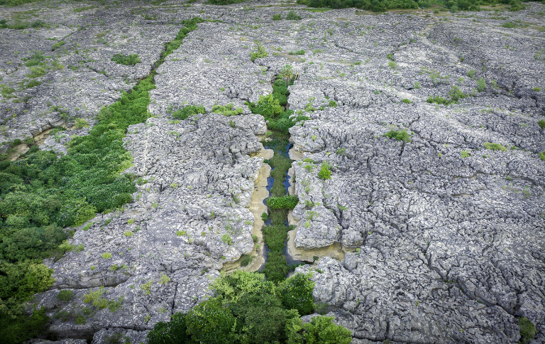
SERRA DA CAPIVARA ARCHEOLOGICAL PARK ‣ a flat-mountain cliffed area with the possibly largest and the oldest concentration of prehistoric sites in the Americas (archaeological and paleontological, despites a huge list of controversial notes; see Current World Archaeology, Issue 37), with many prehistoric arts, with about 1,300 sites, of this 900 with paintings; for many details, see Lourdeal (Bol. Mus. Par. Emilio Goeldi, 2019).
VIOLETO ARTESIAN WELL ‣ here is an extreme lack of information about the artesian wells in Brazil. As artificial structures with a natural flow, they represent a unique category in hydrogeology. It is known that between 264, 300 (SEE), 350 (SEE) or 500 such wells are scattered along a strip about 30 km wide on each side of the Gurguéia River in southern Piauí state (Conejo, ANA, 2005), within the Cabeças Aquifer area, whose spontaneous water discharge is due to the confinement of the Cabeças and Serra Grande aquifers by the Longá and Pimenteiras formations, respectively, throughout the entire valley (about 400 km), ensuring shallow static levels and, occasionally, flowing artesian conditions, which reduce the cost of water extraction (Feitosa, CPRM, 2010). Considerable controversy surrounds these wells, especially regarding the high level of water waste they represent (Folha de S Paulo, 2000). The largest artesian well of Brazil, Violeto I, located in Alvorada do Gurguéia, currently reaches about 25 m in height, though older reports describe jets as high as 70 m. Some sources even describe it as the second largest in the world of its kind — without specifying which one would be the first (Click Petroleo e Gás, 2025).

MIDDLE SÃO FRANCISCO PALEODUNES ‣ a complex of two inative 'fossil' sand fields in left side of Rio São Francscio in NW Bahia state, the largest paleodunes in Brazil: a western bank field, with c. 88 km², and eastern bank with c. 200 km², composed by 'fossil' dunes with heights between 5-10 m to 50-60 m, with an average between 15 and 25 m, and horizontal extent most commonly between 1-3 km, but some parabolic dunes can be over 10 km (SIGEP/CPRM). For trekking in the region, see Youtube/Dunas do Pilão Arcado-BA.
TOCA DA BOA VISTA CAVE ‣ In Brazil, 42 caves are 4 km or longer, but only Toca da Boa Vista exceeds 100 km (Bambuí Speleo).
. composed by Proterozoic dolomites, the largest cave known in Brazil and the 2th southern hemisphere (after Bullita Cave in Australia) with 114 km of mapped galleries, being the 21th in world (Wikipedia), located in the north of Bahia in Campo Formoso municipality (SIGEP/CPRM) - exact location available in Linkedin (SEE).

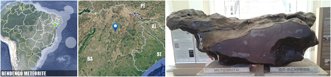
BENDENGÓ METEORITE ‣ the largest known Brazilian meteorite to date, weighting 5.36 tons and measuring 2.15 m ✕ 1.5 m ✕ 65 cm, with a somewhat flattened shape, resembling a riding saddle, and composed mainly of iron and nickel, with smaller amounts of other elements. Despite its colossal size, it's the 16th largest meteorite today, although it was the second largest in weight and size at the time of its discovery, and was found in the interior of Bahia (in the region where the municipalities of Monte Santo and Uauá are located today) and is now housed in the meteorite hall of the National Museum in Rio de Janeiro (Meteoríticas | Carvalho, W.P. et al., Revista Brasileira de Geociências, 2011).
CANUDOS ARID COMPLEX ‣ it is widely recognized in Brazilian geographic culture that the Northeastern semi-arid region is the driest part of the country. In addition, there is broad agreement in identifying a vast area in northern Bahia and southern Pernambuco as the most arid portion of Brazil (MAP | MAP | MAP) — a region we refer to here as the Canudos Arid Complex, which may, in the future, come to be known as the Canudos Desert. This area includes, within its diffuse perimeter, the first technically arid region identified in Brazil, a area of 5,763 km² located in the NC Bahia and covering the entire area of the municipalities of Abaré, Chorrochó and Macururé, in addition of area of Curaçá, Juazeiro and Rodelas, municipalities in Bahia that border the Pernambuco hinterland, revealed in a 2025 study (CEMADEN | MAP) and widely reported in the media (G1), with an aridity index of less than 0.2. It also comprises all sites classified as BSh — hot arid climate — in the Köppen system (Wikipedia), as well as the Raso da Catarina, a striking landscape often portrayed in the media as the 'Brazilian Atacama' (Fundaj | The Summer Hunter), with physiognomic similarities to the desert chaparrals of northern Mexico, the margins of the Kalahari, or the Australian scrublands. The Canudos Arid Complex does not, however, include geographic forms typical of true deserts, such as extensive dune fields, sandstorms, or salt flats.

AGUAS CLARAS CAVE SYSTEM (ACCS) ‣ a cave system located in the municipality of Carinhanha (Bahia), approximately 24 km in length and composed of four limestone caves (Marconi Souza-Silva et al., Biodiversity and Conservation, 2021), recognized as the richest hotspot of subterranean biodiversity in the Neotropical region — 41 identified troglobic species across the following groups: Hexapoda (14), Arachnida (10), Isopoda (6), Diplopoda (7), Gastropoda (2), Turbellaria (1), and Actinopterygii (1). This system surpasses Toca do Gonçalo (also in Bahia) and the Areias cave system (southern São Paulo state), the only other two subterranean biodiversity hotspots known in South America (R. L. Ferreira & Marconi Souza-Silva, Diversity, 2023).

ABROLHOS BANK CORAL REEF ‣ the most extensive area of coral reefs in Brazil and of all the South Atlantic Ocean, however with less than 1% of the reef ecosystems worldwide, in an area of approximately 6,000 km² in the northern part of the Abrolhos Bank; for more details, see Bate Papo com Netuno.
WORLD LARGEST RHODOLITH BED ‣ rhodoliths are nodules of non-geniculate coralline algae that occur in shallow waters (few 150 m depth) subjected to episodic disturbance. Rhodolith beds stand with kelp beds, seagrass meadows, and coralline algal reefs as one of the world's four largest macrophyte-dominated benthic communities, with large concentrations off Japan, Australia and the Gulf of California, Mediterranean, North Atlantic, eastern Caribbean and Brazil. Abrolhos Shelf (16°50′ - 19°45′S) off E Brazil (Bahia and Espírito Santo states) is confirmed the most expansive and contiguous rhodolith bed in the world, covering about 20,900 km² (Amado-Filho, AM et al., Plos One, 2012).

MUCURI CLIFFS ‣ in some points of the coast there are cliffs, a good part of sandy geology. In Brazil these forms occurs in Beberibe, Aracati, Icapuí (CE), Touros, Tibau do Sul (RN), João Pessoa (PB), Roteiro (AL), Mucuri (BA), coast of São Paulo, and highly disjunct in Torres (RS), as independent systems (Saiba Mais, 2021). The site Almanaque Z considers a stretch of Mucuri Cliffs as the longest contunuous in Brazil (SEE), with 2,7 km lenght.
PEDRA RISCADA ROCK ‣ the largest monolith in Brazil and also the largest rocky wall in Brazil, with 950m of extension between base and summit, located in E Minas Gerais state in São José do Divino Municipality, and with a summit reaching 1,230m above sea level — it's sometimes assinated as the largest monolith of the world (CBG/2017).
GARANDELA GIANT PALEOBURROW ‣ c. 2,000 paleoburrows have been found in South America, mostly in the southern Brazil, Uruguay and Argentina (The World), with a record in Rondônia state (G1); Garandela Giant Paleoburrow, in Caeté municipality, SE Minas Gerais state, is possibly the largest worldwide (Ruchkys et al., Caderno de Geografia, 2014), with 340m in lenght; for details about paleoburrows, see Frank et al. (SBP Monographies, 2012).
CENTENARIO CAVE ‣ Ten Brazilian caves reach depths of 200 m or more (Bambuí Speleo).
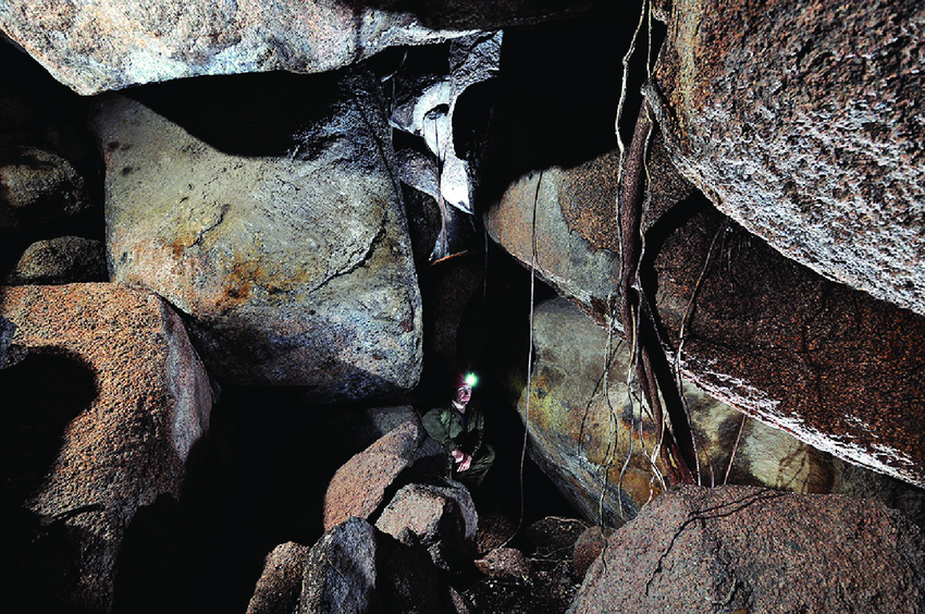
- Centenario Cave, located on Mariana municipality in Minas Gerais state, is the most deep cave in Brazil, with depth between 481 (Bambuí/GPME) and 484m (Bambuí Speleo), being also the deepest in the world in quartzite; in cards, profile plans of the cave [3] and external view of its entrance, which is vertical [4]; more data in Geosítios/Gruta do Centenário.

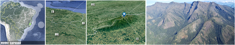
PICO DA BANDEIRA ‣ the highest point of Serra do Caparaó Massif, the second highest maximal point in Brazil (2,896.2m), situated on the border of Espírito Santo and Minas Gerais states, being the highest point in both states and historically considered the highest mountain in Brazil until 1965, when Pico da Neblina, next to the Venezuelan border, were explored, measured, and both found to be higher. This mountains is also remarkable for being the Brazilian mountain with the greatest topographic isolation: 2,344 km — in the Americas, only Aconcagua, Denali, Pico de Orizaba and Mount Whitney are more topographically isolated than Pico da Bandeira, and in the entire world, there are only 20 more isolated mountains (Wikipedia).
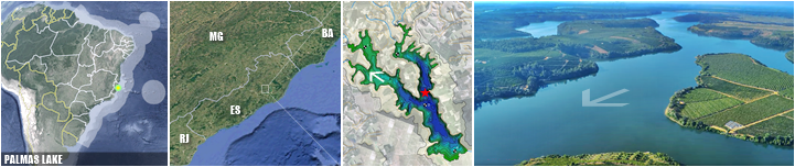
PALMAS LAKE ‣ a lake located in Linhares municipality in Espírito Santo state, with a maximum depth of 50.7m, a volume of 0.22 km³ and a mean depth of 21.4 m, being the deepest natural lake in Brazil (Barroso et al., Plos One, 2014). Several aerial images in YT/Linhares Empregos.
JUPARANÃ LAKE ‣ also in Espírito Santo state, this lake is the largest (62.58 km², Amorim Gonçalves, Dissertation, 2015) and most volumous freshwater lake enterely in Brazil (0.5281 km³, estimative of Almanaque Z, SEE), and second of both features in country, in both cases after Mirim Lake (see below) which reaches into Uruguay.
BRAZILIAN KELP FOREST ‣ Brazil has the unique kelp 'forests' of tropical Atlantic Ocean in Americas (Wernberg et al., World Seas, 2019; also Jayathilake et al., Biological Conservation, 2020), composed by endemic Laminaria abyssalis A.B.Joly & E.C.Oliveira, a deep tropical species prostrate growing up to 5-6m long, from N Espírito Santo coast up to C Rio de Janeiro states, in a small atrea of 33,000 km² (details in Ictiolab/2021); for others images, see Fernandes et al. (BOOK, 2021).
TRINDADE AND MARTIM VAZ ISLANDS ‣ Trindade and Martim Vaz (besides individual status of these islands) is an archipelago with 10.4 km² located in the South Atlantic Ocean about 1,100 kilometres east of the coast of the Brazilian state of Espírito Santo and the most disconex portion of territory, of which it forms a part; there are six islands and numerous rockes, being Trindade mountainous, desiccated volcanic island with numerous phonolitic lava domes and steep-sided volcanic plugs reaching up to 620 m; South Island near Martim Vaz is the easternmost point of Brazil (28°51′00″W); there is a small settlement in the north on the shore of a cove called Enseada dos Portugueses, supporting a garrison of the Brazilian Navy, 32 strong (Wikipedia).
BRAZILIAN ATLANTIC DEEPEST POINT ‣ the lowest point of the Brazilian EEZ and, therefore, of the entire national territory, can be found by accessing the Ocean Basemap (SEE), activating 'layers', selecting ArcGIS Online mode, searching for 'Brasil ZEE', and activating the correct layer for a visual search. Then, the Bathymetric Data Viewer (SEE) helps to obtain the exact point. The exact point is located at the approximate coordinates of 25°43'12" W 19°25'40.8" S, reaching a depth of -6182m, and does not have an official name, being 348 km from Martim Vaz island and 1,430 km from the mainland, at the latitude of Bahia.
CABO FRIO UPWELLING ‣ upwelling is a phenomenon in the oceans where cold deep waters rise to the surface of the sea, in complex systems involving the Coriolis effect, wind systems, and the rotation of the Earth. The largest systems are located off the western coasts of continents, although they occur at various points (SEE). Coastal upwelling occurs on the Brazilian shelf in three different regions: off southern Bahia (15° S–19° S), off Cabo Frio (20° S–24° S), and off Cabo de Santa Marta (Kaempf & Chapman, BOOK, 2016). The most prominent of these systems is the Cabo Frio Upwelling System (CFUS). The spatial extension of the upwelling and the temperature anomalies associated with it are about 500 km and -4.5°C at 23°S, respectively (Santos, F.H. et al., SBSR, 2015). This phenomenon makes the waters significantly colder compared to the ambient temperature, especially between August and September, while also providing a high density of nutrients (Olhar Oceânico, 2023).

BRAZILIAN ASPHALT SEEP ‣ Brazil has only three chemosynthetic ecosystems at their sea, one is Brazilian aspahlt seeps, escarpment of asphalt on the seafloor relief, known only in 2013, the only representing only the third discovery of this type of seep worldwide, following those in the Gulf of Mexico and off Angola (Fukujima et al., DSRP II, 2017); Brazilian souces has a total length of approximately 5.6 km (Jiang et al., Scientific Reports, 2018).
SALT LAKE ‣ this lake in northern coast of Rio de Janeiro state contains the unique ocurrence of recent columnar carbonate stromatolites of whole of Brazil and probably of the South America (SIGEP); for more details, see Geoparques Costões e Lagunas (SEE) and Ambiente Cult (SEE, 2009).
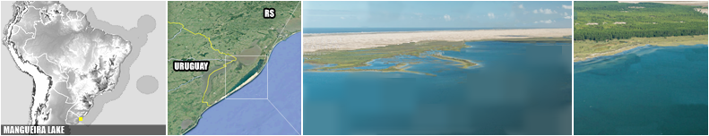
ARARUAMA LAKE ‣ Araruama Lake, located in Rio de Janiero state, is the largest body of permanent hypersaline water in the world, with 220 km², surpassing other prominent hypersaline water bodies such as the Great Salt Lake (United States), Lake Coorong (Australia), Lake Enriquillo (Dominican Republic) and the Lagoon Ojo de Liebre in Mexico (Wikipedia), the second largest saltwater lake in Brazil after Mangueira Lake.
FORNO BEACH PINK SANDS ‣ there is no official catalog of the number of beaches in Brazil - however, Guia 4 Rodas, a popular Brazilian travel and automotive magazine, listed 2,095 beaches in its 2007 edition (Mar Sem Fim). There is also no official survey in the country regarding beaches with non-conventional sand colors — typically in shades of black or pink. Among Brazilian beaches, Praia do Forno in Arraial do Cabo, Rio de Janeiro, is often mentioned for having pink sand, caused by the weathering of garnet mixed with shells and corals (Viagem e Turismo | Turismo Buzios). It is included in such lists due to its remarkable aesthetics and because it is the most widely known national example under this criterion.

NEBLINA WATERFALL ‣ Brazil has 28 waterfalls that are 200 m tall or higher, spread across eight states and mostly concentrated in the southern region — however, the tallest waterfall in Brazil of them is Neblina Waterfall, standing at 450 m high, located in the Serra dos Órgãos National Park, in Guapimirim municipality, Rio de Janeiro state (Cachoeiras Gigantes).
GÁVEA ROCK ‣ a monolithic rock in Tijuca Forest, Rio de Janeiro, Brazil, composed of granite and gneiss, its elevation is 844m, being the world's largest monolith on the coastline (Wikipedia).
OLDEST JACARANDA OF ITUTINGA ‣ a xylopodic individual of Jacaranda decurrens Cham. (Bignoniaceae, native to C Brazil, Paraguay and Bolivia) from Itutinga, in southern Minas Gerais state, with an estimated age of 3,801 years, is probably the oldest living organism in Brazil and the oldest angiosperm in America Latina, surpassing an individual of Fitzroya cupressoides (Mol.) Johnst. (Cupressaceae) from Chile, which has an age of 3,622 years (Alves, R. J. V. et al., Anais da Academia Brasileira de Ciências, 2013). The oldest known organism is likely a specimen of Posidonia oceanica (L.) Delile located near the Balearic Islands in Spain (Wayback Machine).

HIGHEST SPRING IN BRAZIL ‣ there are no official records in Brazilian scientific literature identifying the highest spring in the country, nor are there consolidated data on springs located in Brazil’s highest mountain ranges. However, a strong candidate for this title — and considered one of the nation’s natural treasures — is a spring located east of the summit of Pico das Agulhas Negras in Minas Gerais's side (see in map at PN Itatiaia), the highest peak of the Itatiaia massif, at an elevation of approximately 2700 m. If a higher spring does exist, it is likely to be found in either the Caparaó Massif or the Neblina Massif.

SERRA DA MANTIQUEIRA ‣ a mountain range formsing the highest continuous orographic system in eastern South America (Marques Neto, Revista Brasileira de Geomorfologia, 2017) and is one of the country’s oldest and most significant mountain complexes (Cipriano da Silva et al., Revista Ciência Afronômica, 2022). In the more conservative definition adopted here, it extends across NE São Paulo, SE Minas Gerais, and SW Rio de Janeiro states (Teramoto & Vilanova, Journal of South American Earth Sciences, 2024), within the Atlantic Forest domain — known for its exceptional species richness and endemism (Campos-Mota et al., Phytotaxa, 2022). The range contains 5 of Brazil’s 8 maximal points (Almanaque Z/2025), as well as the nation’s highest city and several other altitude-related records.

CAMPOS DO JORDÃO ‣ the highest settlement in Brazil (46,974 inhabitants in 2022, IBGE), with its seat located at 1,639.2 m above sea level (IBGE) — however, the city's urban sprawl extends into even higher areas, with streets and residences reaching elevations above 1,700 m on the Campos do Jordão Plateau, a crystalline block plateau bounded by steep escarpments that rise approximately 1,500 m above the hills of the middle Paraíba Valley, in the NE part of the state of São Paulo (Modenesi-Gauttieri & Hiruma, Revista do Instituto Geológico, 2004). In the ranking of the largest settlements by country, Campos do Jordão holds the distant 69th position worldwide and the 16th in the Americas (Wikipedia).

QUEIMADA GRANDE SNAKE ISLAND (QGSI) ‣ an island of 0.45 km² off the coast of Brazil in the Atlantic Ocean at 35 km of continent, famous for its abundant snakes (Bothrops insularis Amaral, 1922, 2,000 to 4,000 snakes, Discover Wild Life), administered by municipality of Itanhaém in São Paulo state, covered by bare rock to rainforest (Wikipedia). This island ranks second worldwide in snake concentration, surpassed only by Shedao Island in China, which harbors around 20,000 snakes. A second snake species, Dipsas mikanii Schlegel, a non-venomous species, is also found on the island (National Geographic Brazil). In 2025, MrBeast — then considered the world's biggest YouTuber — named QGSI the most dangerous place on Earth, cementing the island’s place in global pop culture (G1).

CASA DA PEDRA CAVE ‣ only five caves in Brazil have entrance portals measuring 70 m or more (Bambuí Speleo), the largest of which is the entrance of the Casa da Pedra cave — a cave located within forested mountains in the southern part of the state of São Paulo (Iporanga municipality), in the Atlantic Forest region. It is the largest cave entrance in the world, recognized by the Guinness Book, with an astonishing height of 215 m (PETAR).

PEABIRU ANCIENT ROUTES ‣ a ancestral network of trails dating back more than 3,000 years connected the Atlantic and Pacific Oceans, running through Brazil, Paraguay, and Bolivia, and reaching as far as Peru (some branches extend toward Mato Grosso do Sul, Argentina, and Rio Grande do Sul, Atlas do Chão). This network is highly controversial (rejected by National Institute of Culture of Peru, Campo Grande News), marked by disputes among government agencies, civil organizations, historians, and authorities (IELA/UFSC), and strongly fueled by theories and speculation. Existing maps of the route are vague, and rigorous surveys are still underway (Blog Caiçara). In Santa Catarina state, the Peabiru is associated with the saga of Aleixo Garcia, often cited as the first European to reach the Andean Empire (Cultura Uol | DW). In the state of São Paulo, the Peabiru is believed to have branched across the southern and central regions, extending up to 5,000 km (Melhores Destinos). In Paraná, mapping efforts are more advanced, producing a more detailed route that includes 97 municipalities (Caminhos do Peabiru | MAP). The routes of the Peabiru in Paraguay, Bolivia, and Peru remain unknown or highly imprecise.

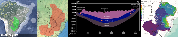
GUARANY AQUIFER ‣ often mistaken as 'an underground lake or river', aquifer are like an underground sponge — buried layers of sand and gravel saturated with water. Guarani Aquifer System represents the second largest aquifer in the world (after Great Artesian Basin, in Australia, SEE) and the largest in Brazil, occupying 950,000 km² within the Paraná sedimentary basin at 8 states, reaching also in othre three countries: Argentina, Paraguay, and Uruguay; 90M people are directly or indirectly benefitting from the GAS exploitation (Teramoto, Gonçalves & Chang, Journal of Hydrology: Regional Studies, 2022).
GUARTELÁ CANYON ‣ a Brazilian canyon located on the Campos Gerais plateau, between the municipalities of Castro and Tibagi in the Paraná state — it is considered the sixth longest canyon in the world and the longest in Brazil. The Guartelá Canyon is a straight, narrow gorge measuring approximately 30 km in length, with a maximum depth of 450 m. It was carved by the Iapó River, which cuts through the devonian escarpment— the geological wall that separates the first and second plateaus of Paraná (Wikipedia).
IGUAZU FALLS ‣ extremelly famous, are waterfalls of the Iguazu River on the border of the Argentine province of Misiones and the Brazilian state of Paraná; together, they make the eight volumous waterfall system in the world (ignoring Paulo Afonso falls, which has an artificial flow resulting from damming) and largest of Brazil, 35 and 40m in height and with an average rate of 1,746 m³/s; its maximum recorded flow was 45,700 m³/s on 9 June 2014 (Wikipedia).
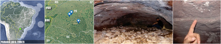
PARANÁ LAVA TUBES ‣ in Brazil, only four lava tubes are known: Casa de Pedra and Perau Branco (both in the municipality of Palmital), Dal Pae (municipality of Marquinho), and Pinhão (municipality of Pinhão), all located in southern Paraná state (SINAGEO/2016). For details on the first two, see Waichel, B.L. et al (Journal of South American Earth Sciences, 2013).
SOUTH AMERICA TORNADOES CORRIDOR ‣ southeastern South America has one of the most active corridors on the planet, spanning mainly N Argentina, S Brazil, Uruguay, and Paraguay, being one of the most dynamic and violent meteorological environments in the Southern Hemisphere — the USA is the world leader in recorded tornadoes — averaging about 1,225 per year (G1). Almeida (IC/UEPG, 2023) lists records of tornadoes from 1978 to 2018 indicate 581 events in Brazil, spread across 422 municipalities, 159 of which reported more than one occurrence — the southern states dominate overwhelmingly (411): Rio Grande do Sul (180), Santa Catarina (142), and Paraná (89).

AMETHYST WORLD LARGEST MINES ‣ amethyst is a variety of quartz containing tetravalent iron ions, which give it its purple color — quite common in Brazil and occurs in several lithologies. However, commercially valuable forms are far rarer and more spatially restricted. The region of Ametista do Sul hosts one of the largest amethyst deposits in the world, due to the concentration and quality of the stones, formed by four mineralized lava flows that created basalt layers containing amethyst geodes. Economically, amethyst extraction takes place in eight municipalities in Rio Grande do Sul, with more than 200 active mining sites (Click Petroleo e Gás). About 95% of the production is exported to China, USA, and European countries, generating roughly R$ 500 million per year for the state’s economy. (Brazil Mineral)

YACUMAN FALLS ‣ this falls are an important set of waterfalls between Derrubadas, in Rio Grande do Sul state, and El Soberbio, in the Argentine province of Misiones; it is the largest longitudinal waterfall in the world, measuring 1,800m in length and reaching a height of up to 20m (Wikipedia).


/s.glbimg.com/jo/g1/f/original/2011/12/26/lajedo1.jpg)